These amazing black and white photographs capture old Berlin in 1959.
 |
| This view is looking into East Berlin from the western sector. The border lies 40 metres past the notice. Despite what was commonly thought, the whole of the Brandenburger Tor was in East Berlin. |
 |
| Unter den Linden was the boulevard in East Berlin encountered after passing through the Brandenburger Tor. This view looks further east into the communist sector. |
 |
| Stalinallee was later renamed Karl Marx Allee. |
 |
| The People’s Police checking documents of people entering Potsdamer Platz S-Bahn. Picture taken from West Berlin. |
 |
| This cafe at Potsdamer Platz was just inside West Berlin, with the pavement in the West and the road in the East. The man is reading NEUES DEUTSCHLAND, the communist East Berlin newspaper. |
 |
| Glienicker Bruecke (Glienicke Bridge) is on the edge of Berlin at Lake Havel, and was on the border with East Germany proper (not East Berlin). It was the scene of a number of spy exchanges during the Cold War. |
 |
| Kurfuerstendamm, West Berlin. |
 |
| Kurfuerstendamm, West Berlin. |
 |
| Kurfuerstendamm, West Berlin. |
 |
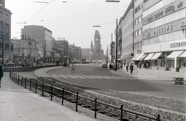
| Tauentzienstrasse meets Kurfuerstendamm at the ruin of the Kaiser Wilhelm memorial church, which can be seen in the distance. On the extreme left can be seen the edge of KaDeWe, the largest department store in mainland Europe. |
 |
| The bombed ruin of one of the twin churches in Gendarmenmarkt, East Berlin. |
 |
| Political posters near Friedrichstrasse station, looking north along Friedrichstrasse. |
 |
| The view looking north along Friedrichstrasse at the junction with Unter den Linden. |
 |
| Tauentzienstrasse, looking towards Wittenbergplatz. |
 |
| Scene somewhere near the Zoo in West Berlin. The building with the chequered motif in the centre-left distance later became the Hilton hotel. |
 |
| The bombed building was on the north side of Unter den Linden in East Berlin, very near the Brandenburger Tor, with the Reichstag beyond it being in West Berlin.
These amazing black and white photographs capture old Berlin in 1959.
 |
| This view is looking into East Berlin from the western sector. The border lies 40 metres past the notice. Despite what was commonly thought, the whole of the Brandenburger Tor was in East Berlin. |
 |
| Unter den Linden was the boulevard in East Berlin encountered after passing through the Brandenburger Tor. This view looks further east into the communist sector. |
 |
| Stalinallee was later renamed Karl Marx Allee. |
 |
| The People’s Police checking documents of people entering Potsdamer Platz S-Bahn. Picture taken from West Berlin. |
 |
| This cafe at Potsdamer Platz was just inside West Berlin, with the pavement in the West and the road in the East. The man is reading NEUES DEUTSCHLAND, the communist East Berlin newspaper. |
 |
| Glienicker Bruecke (Glienicke Bridge) is on the edge of Berlin at Lake Havel, and was on the border with East Germany proper (not East Berlin). It was the scene of a number of spy exchanges during the Cold War. |
 |
| Kurfuerstendamm, West Berlin. |
 |
| Kurfuerstendamm, West Berlin. |
 |
| Kurfuerstendamm, West Berlin. |
 |
| Tauentzienstrasse meets Kurfuerstendamm at the ruin of the Kaiser Wilhelm memorial church, which can be seen in the distance. On the extreme left can be seen the edge of KaDeWe, the largest department store in mainland Europe. |
 |
| The bombed ruin of one of the twin churches in Gendarmenmarkt, East Berlin. |
 |
| Political posters near Friedrichstrasse station, looking north along Friedrichstrasse. |
 |
| The view looking north along Friedrichstrasse at the junction with Unter den Linden. |
 |
| Tauentzienstrasse, looking towards Wittenbergplatz. |
 |
| Scene somewhere near the Zoo in West Berlin. The building with the chequered motif in the centre-left distance later became the Hilton hotel. |
 |
| The bombed building was on the north side of Unter den Linden in East Berlin, very near the Brandenburger Tor, with the Reichstag beyond it being in West Berlin. |
|


